Tramways à Düsseldorf - Trams in Düsseldorf
| Réseau de tramway de Düsseldorf | |||||||||||||||||||||||
|---|---|---|---|---|---|---|---|---|---|---|---|---|---|---|---|---|---|---|---|---|---|---|---|
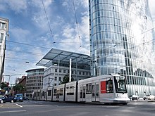
 Un tramway de Düsseldorf à Graf-Adolf-Platz .
| |||||||||||||||||||||||
| Opération | |||||||||||||||||||||||
| Lieu | Düsseldorf , Rhénanie du Nord-Westphalie , Allemagne | ||||||||||||||||||||||
| |||||||||||||||||||||||
| |||||||||||||||||||||||
Le réseau de tramway de Düsseldorf (en allemand : Straßenbahnnetz Düsseldorf ) est un réseau de tramways desservant Düsseldorf , la capitale de l' État fédéral de Rhénanie du Nord-Westphalie , en Allemagne. En combinaison avec le Düsseldorf Stadtbahn et le Rhin-Ruhr S-Bahn , il constitue l'épine dorsale du système de transport public à Düsseldorf.
Le réseau de tramway est actuellement exploité par Rheinbahn AG et intégré au Verkehrsverbund Rhein-Ruhr (VRR). En 2016, ses sept lignes de tramway parcouraient 78,0 kilomètres (48,5 mi) de parcours, desservant 178 arrêts.
Histoire

En 1876, la première ligne de tramway hippomobile a ouvert à Düsseldorf exploitée par l'entrepreneur belge Léopold Boyaert . Elle rejoignait la place du Château avec la gare Bergisch-Märkischen et la salle de concert.
En 1896, le premier tramway électrique a fonctionné à Düsseldorf et la conversion complète du système à l'électricité s'est poursuivie jusqu'en 1900.
Lignes
En 2016, sept lignes de tramway circulant sur 78,0 kilomètres (48,5 mi) de parcours, fonctionnent dans la ville de Düsseldorf et dans certaines parties des zones urbaines de Neuss :
| Ligne | Route | Arrêts | Durée | Takt Lu.–Ve. / Sa. / Su. |
|---|---|---|---|---|
| 701 | (ISS Dome (en construction)) - D-Rath |
28 | 35 minutes | 10/10/15 (20/20/30) |
| 704 | Merziger Straße – Straßburger Straße – Alter Schlachthof –plutôt Straße / Hochschule HSD – St.-Vinzenz-Krankenhaus – Lennéstraße – Stockkampstraße – Rochusmarkt – Adlerstraße – Pempelforter Stra –e |
21 | 29 min bis Uni Nord / 30 min bis Botanischer Garten | 15/10/15 (-/-/15) |
| 705 |
D-Unterrath |
32 | 43 minutes | 10/10/15 (20/20/30) |
| 706 |
D-Hamm |
35 | 51 minutes | 15/10/15 |
| 707 |
D-Unterrath |
29 | 43 minutes | 10/10/15 |
| 708 | Heinrichstraße – Hansaplatz – Grunerstraße – Brehmplatz – Schillerplatz – Uhlandstraße – Birkenstraße – Worringer Platz – Hauptbahnhof – Stresemannplatz – Berliner Allee – Graf-Adolf-Platz – Poststraße – Landtag / Kniebrückedium – Polizeipräsi
|
15 | 23 minutes | 20/-/- |
| 709 |
Gerresheim , Krankenhaus - Heinrich-Könn-Straße - Auf der Hardt / LVR-Klinikum - Pöhlenweg - (Grafenberg, Staufenplatz) - Burgmüllerstraße - Schlüterstraße / Arbeitsagentur - Engerstraße - Hoffeldstraße - D-Flingern |
33 | 54 minutes | 10/10/15 (20/20/30) |
Après avoir terminé les travaux à la Wehrhahlinie , de nombreuses lignes de tramway (703, 712, 713 et 715) ont été déplacées vers le nouveau service Stadtbahn .
Matériel roulant
La flotte de tramways actuelle se compose de tramways à plancher bas qui sont bons pour l'accessibilité en fauteuil roulant.
Voir également
- Düsseldorf Stadtbahn
- S-Bahn Rhin-Ruhr
- Rhein-Ruhr Stadtbahn
- Verkehrsverbund Rhein-Ruhr
- Liste des systèmes de tramway urbain en Allemagne
- Les tramways en Allemagne
Les références
Remarques
Bibliographie
- Höltge, Dieter (1994). Straßen- und Stadtbahnen in Deutschland [ Tramways et Stadtbahnen en Allemagne ] (en allemand). Bande 4: Ruhrgebiet - Von Dortmund bis Duisburg [Volume 4: Ruhr - de Dortmund à Duisburg]. Fribourg i. B., Allemagne : EK-Verlag. ISBN 9783882553345.
- Nolden, Hans G (1998). Die Düsseldorfer Straßenbahn [ Le tramway de Düsseldorf ] (en allemand). Munich : GeraMond Verlag. ISBN 3932785029.
- Schwandl, Robert (2012). Tram Atlas Deutschland de Schwandl (en allemand et en anglais) (3e éd.). Berlin : Robert Schwandl Verlag. p. 46-48. ISBN 9783936573336.
Liens externes
- Rheinbahn - site officiel (en allemand)
- Rheinbahn - site officiel
- Plan du réseau de Düsseldorf (pdf)
- Base de données / galerie de photos de Düsseldorf et liste des tramways de Düsseldorf à Urban Electric Transit - en plusieurs langues, dont l'anglais.
- Base de données / galerie de photos de Düsseldorf chez Phototrans – en plusieurs langues, dont l'anglais.

